|
This will be a bit of a different blog post today. Normally I talk about our local weather and climate and their patterns. Today I will be writing on an area I have a large interest in, the connections between anthropogenic climate change and severe weather (here and here.) I was inspired by the severe weather in December which were followed by a media frenzy on the freak severe weather to end 2021 and how the changing climate caused them. I'll talk about whether they were unique and how severe weather can change with the warming climate. Let's get into some of the basics on climate change before moving forth. Back to BasicsFor one thing, global warming and climate change are technically different things. Global warming is simply the rise in global air temperatures, while climate change is the change in climate over time due to the global warming. Greenhouse gases like CO2, water vapor, Methane, among others helps trap heat radiating off the surface after its absorbed as incoming solar radiation. Without these greenhouse gases, the earth would essentially be locked in an unending ice age. 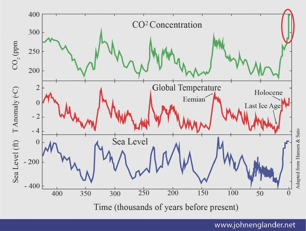 Correlation between CO2 concentrations, global average temperature and sea level over the past 400,000 years. Now of course too much of a good thing could be a bad thing as well. 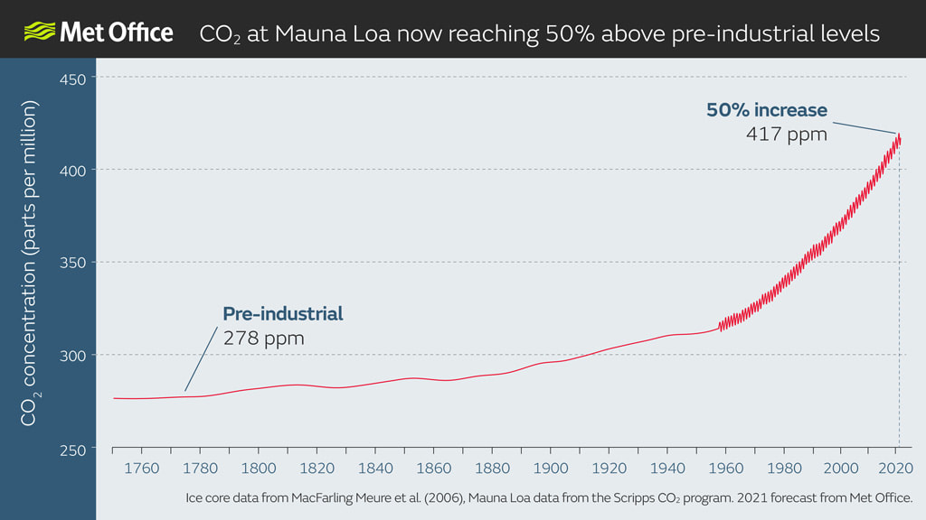 Global atmospheric CO2 concentrations from 1700 to 2021. Credit: Met Office. Also data from 1960 onward shows seasonal variation at the Mauna Loa data site. From the first graphic you can see with more atmosphere carbon comes higher temperatures and more CO2 has been pumped into the atmosphere since the dawn of the industrial revolution. in 1770 the concentration of CO2 was 278 ppm and now it sits at 417 ppm. There are other climate drivers, such as volcanic eruptions, variation in solar output (solar cycles,) and variation in Earth's orbit (Milankovitch cycles.) Greenhouse gases are the biggest driver though. With higher temperatures, glaciers recede and melt which adds to sea level rise in a positive feedback loop. The idea of climate change is somehow still being debated, but I am not here to debate. The scientific consensus is that human activity is the primary driver of modern-day climate change. The climate has always changed through our understanding of past greenhouse gas concentrations in ice cores, and tree rings. There have been large upheavals in earth's climate like during the medieval warm period, the little ice age, and after large volcanic eruptions, but what we are seeing today is of our own doing. Now on to the basics of severe weather. There are many types of severe weather, but for sake of brevity we will be focusing on severe convective weather (thunderstorms and tornados.) For thunderstorms you need three main ingredients, moisture, instability, and lift. For severe thunderstorms we add a fourth ingredient, wind shear. First you need a high dewpoint which means there is plenty of water vapor to form clouds. Next you need the instability or warmer air near the surface and increasingly cooler air the higher you go up. Warm air is less dense than cold air, so a parcel of warm air wants to rise (convection.) You can get a parcel of air to rise on its own when its really warm like in the summer, but a boundary like a cold or warm front, even mountains can help lift the parcels up. Wind shear is the change in wind with height. It can either be change in direction and/or speed with height. When you get the updraft of a severe thunderstorm to rotate it becomes known as a mesocyclone and found in supercells which is the type of thunderstorm most tornados come from. It can also tilt the updraft which helps a storm survive longer as the cold downdraft doesn't choke out the warm updraft too early. The two most important ingredients are CAPE (Convective Available Potential Energy; a measure of Instability) and wind shear. 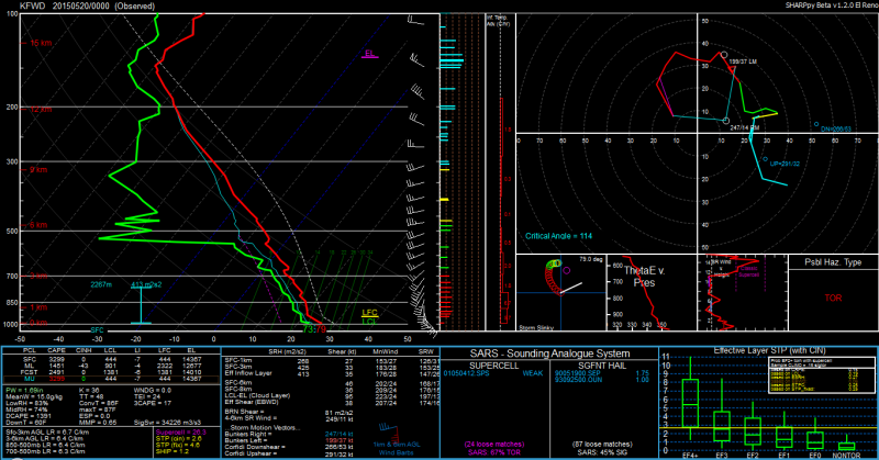 Skew-T chart showing vertical thermodynamic profile and hodograph Now time to look at how climate change could affect severe weather. I will apologize in advance if I get a bit technical, I will try and break down everything that I can. Connections and the FutureI should preface this that since that severe convective weather is the least understood of severe weather, so it's hard to put into relation with climate change which is a very large scale process. We understand extremes in temperatures and precipitation with the future implication of climate change. We still don't understand severe convective weather too well since its so small scale, so its quite hard to understand the effect of climate change on the future. 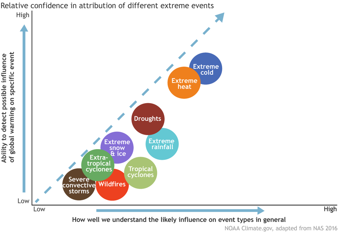 Tornados and thunderstorms for that matter are pretty small (on the order of mesoscale to microscale) and can't be seen on global or climate models. It takes high resolution models or convection allowing models like the HRRR or NAM3k to see even general shapes of thunderstorms. Models like the NAM or GFS use what is called parameterization to simplify the very fine process that cause thunderstorms. All that to say our current gridded climate models cant make out thunderstorms so climatologists and meteorologists have a work around. We know the two main ingredients for severe weather is instability and wind shear, so we can infer that days with both of those could produce thunderstorms. A big question is with a warming climate, could we see more severe thunderstorms. Studies normally account for increased greenhouse gas emissions and mean temperature increase between 2 deg C - 6 deg C through the 21st century. A basic principle with warm air is that it can hold more moisture. You could have a day with 100% humidity in the winter, but it stills feels bone dry since cold air just can't hold a lot of water vapor. With more water vapor in the air and boundary layer, we can see an increase in instability. More instability can help with more convection and stronger updrafts in storms. As for the other component, vertical wind shear. Several papers found that levels of CAPE (instability) increased, but indices of high vertical wind shears values decreased. This doesn't mean chances of severe weather go down. Chances would actually go up, with more days with high instability values. You really need a balance between instability and shear, and as long as both are present in some amount, there is always the possibility for severe weather. Now back to why I wrote this blog post. With a clearly higher than average number of tornados in December 2021. While it is obviously usual to have severe weather in the winter months, severe weather can happen all months of the year. 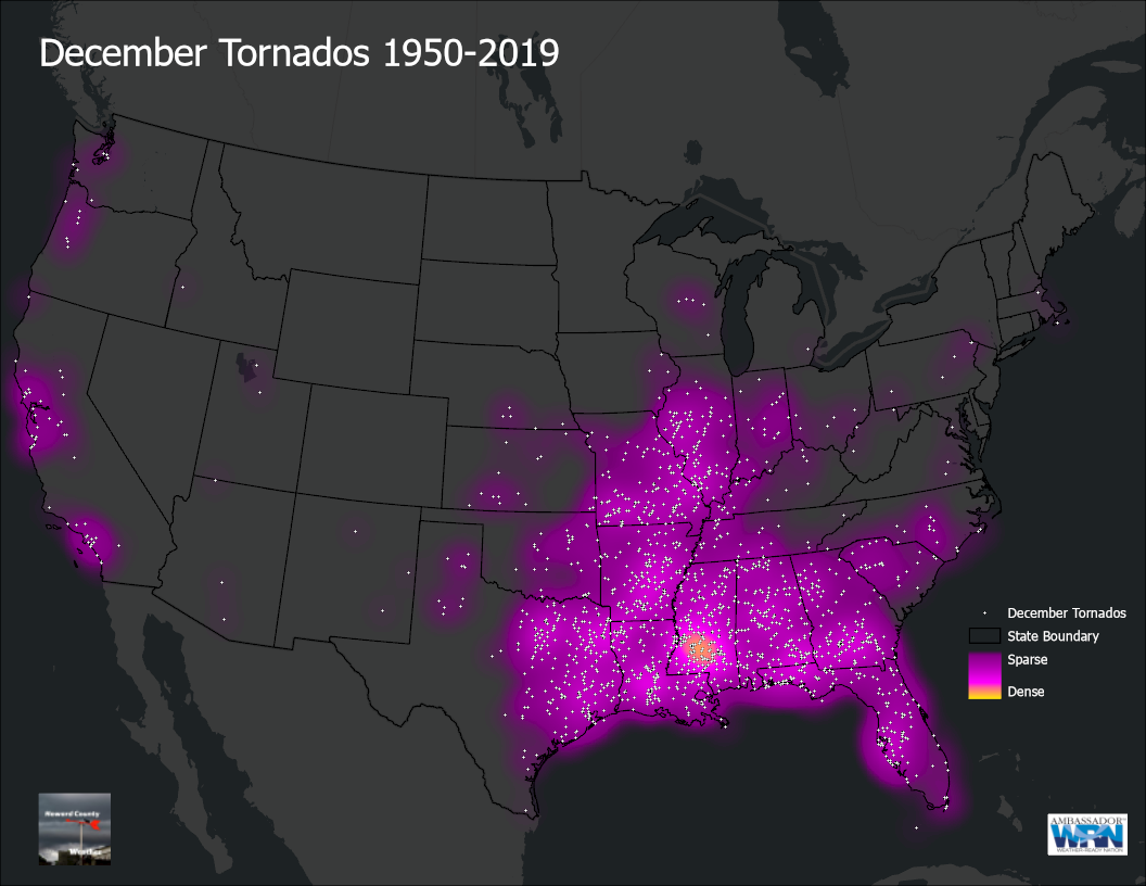 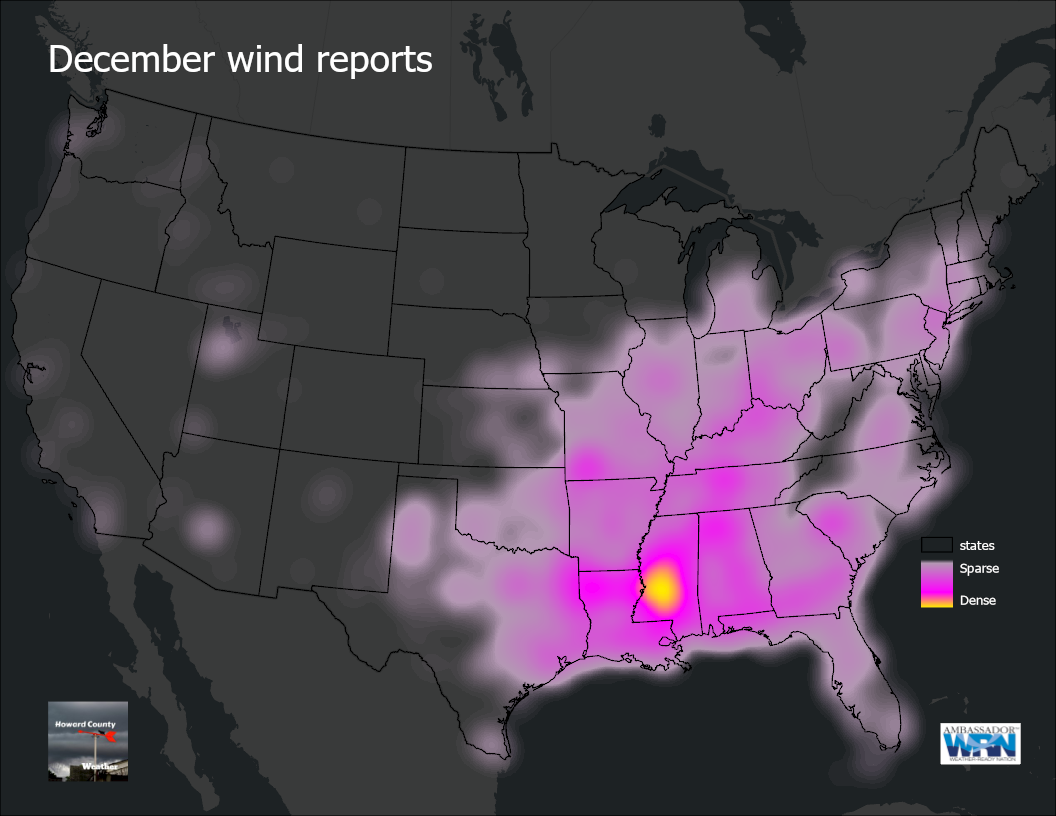 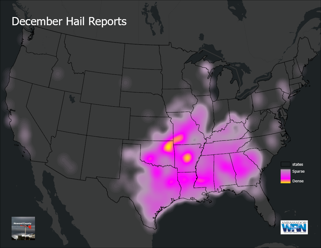 Since thunderstorms need instability so it makes sense that most December tornados are relatively close to the Gulf of Mexico along with wind reports. There do seem to be hotspots around population centers like Jackson, MS. 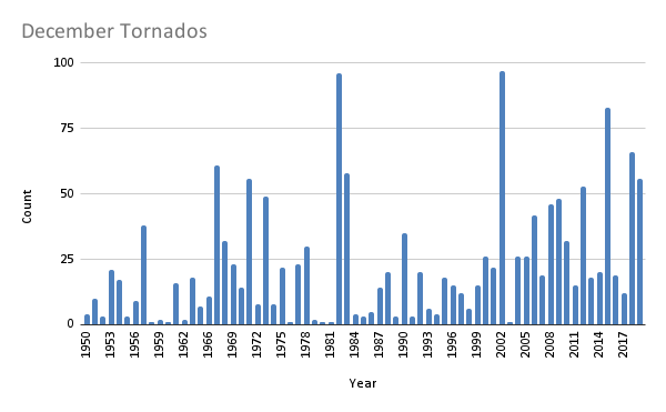 As I said earlier its not uncommon to have quite a few tornados reported in the month of December. With warming winters, there is the possibility of seeing more tornados on average during winter months, including December. According to NOAA "the likelihood of a tornado occurring on a December day in the U.S. is 12-15%. By contrast, the likelihood of an early June tornado is 90%. And although they are not as common, December tornadoes can still cause significant damage. Since 1879, 22 EF-4 and EF-5 category tornadoes — the most destructive — have occurred in December."
The point is that you should be on guard any month, not just spring or summer and there is a possibility that more severe weather could occur with a changing climate through extreme climate attribution.
0 Comments
|
 RSS Feed
