
|
I hope everyone had a great restful Thanksgiving and a stomach full of Turkey. On Thursday, our high temperature was 59 deg while our average high is normally 48 deg. While we were over 10 deg warmer than average we were still cooler than our record high of 70 deg set in 1927. Temperature wise the month of November has been close to average with the notable cooldown mid-month. With the exception of parts of the snow belt we have been dry just getting 25-75% of our normal precipitation amount. Before I get into my thought on the upcoming winter, let's talk about the next week or two. Both the American and European ensemble models agree we will start on a warm note.
Cold should return around the 5th/6th based on several teleconnections going into cooler phases around that time such as the NAO going quite negative. Actually there is modeling showing a *potential* snowstorm to our north around the 7th. I promise our time for that will come. The BasicsBefore I go into the outlook, I would like to explain what I llok for in making one.
Sea Surface Temperatures and ENSO The largest driver probably would be SSTs and ENSO which influence the teleconnections and jet streams. 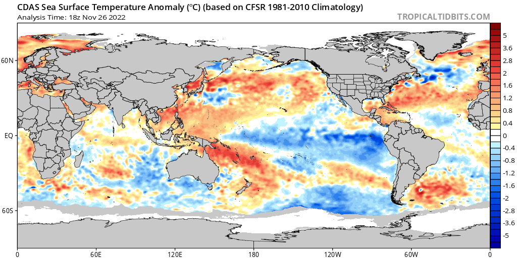 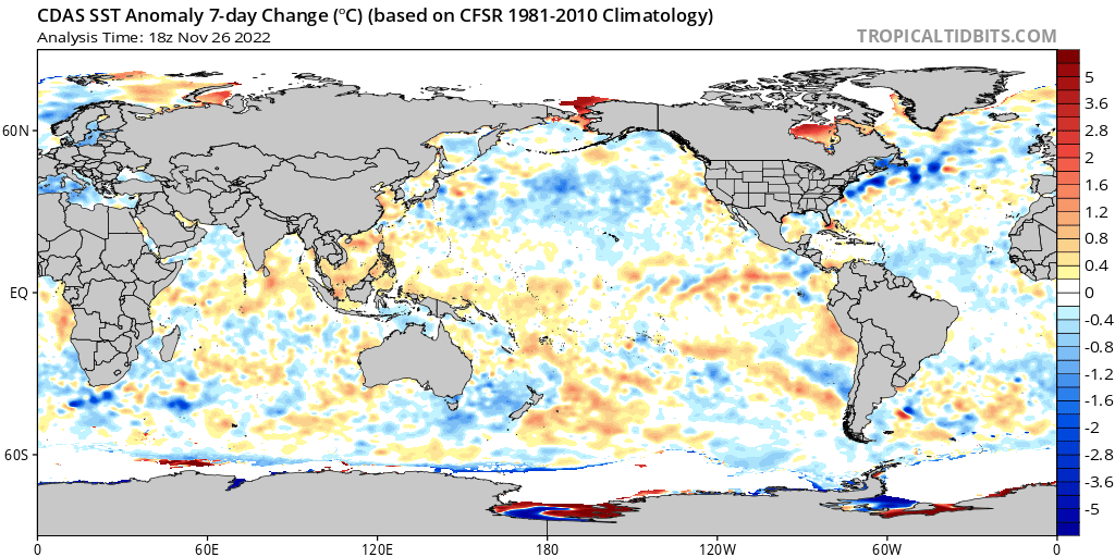 Take a look at the Bering Sea, the Central Pacific, and south of Greenland. These areasd are important to llok at with teleconnections. Warmer anomalies suggest rising motion and cool anomalies suggest sinking motion in the atmosphere and hence troughs and ridges. ENSO or the El Nino Southern Oscillation is basically the shifting of trade winds in the central Pacific Ocean basicly either allows cooler water to upwell off the peruvian coast or not. ENSO has a cool phase (La Nina), a warm phase (El Nino), and a neutral phase. The large basin wide cool water anomalies show a classic La Nina. Looking at the seven day changes there is some warming of the central pacific basin. The Climate Prediction Center is forecasting a weakening LA Nina and neutral to El Nino conditions by next winter. 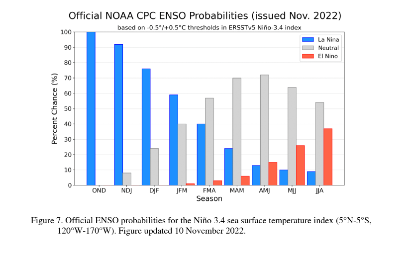 Regardless, it looks like a triple dip La Nina winter. Teleconnections In short, teleconnections are atmospheric anomalies affecting the weather pattern of a distant area. Some of these teleconnections I look at would be the North Atlantic Oscillation (NAO), Arctic Oscillation (AO), Eastern Pacific Oscillation (EPO), Pacific-North American Teleconnection Pattern (PNA), and Madden-Julian Oscillation (MJO). A teleconnection gives a general idea of the atmospheric patter which can lead to cold, snowy weather vs calm and mild. Teleconnections are more short-term influences, but they influence the wider pattern of the jet stream. You can have either a meridional or zonal flow. A zonal flow if kind of flat allowing for calm weather, while a meridional flow features kinks in the jet stream allowing more extremes to occur. 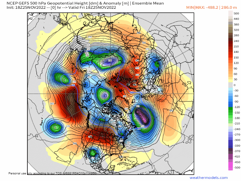 You can imagine the jet stream as having waves so think if you have a ridge on the west coast, there will likely be a trough downstream in the central and eastern US. Likewise with a ridge south of Greenland. The perfect combination for cold in the eastern US would be a -AO, -NAO, -EPO, And +PNA. If you have all agreeing on cold, but one suggests warmth they will destructively interfere with each other. In my experience it is getting a ridge on the west coast (a +PNA) to develop at the same time the rest are negative. Soil Moisture Soil moisture isn't as important right now, but more for next spring. Lots of moisture in the soil can be evaporated and substain storm systems when they pass through. If the soil is dry there won’t be as much moisture to work with unless the system can tap into more tropical moisture from the Gulf of Mexico. To get a lot of precip you want lots of moisture. Even if you have rising motion, if it’s dry you won’t end up with a too strong of a system. A concern is if we don’t get a lot of moisture in the next few months we will start in a moisture deficit in the spring that could continue into summer. Just something to keep an eye on. 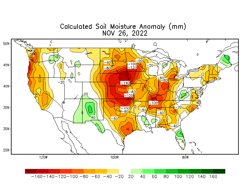 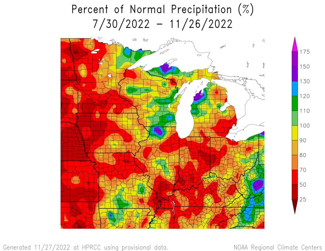 Analogs Analogs are years with similar atmospheric conditions that can help us clue into what could happen. With this winter being a rare triple dip La Nina year. With the lack of good data to really depend on, I'm more inclined to look more closely at everything else. Polar Vortex The polar vortex is a large area of low pressure that exists over both poles. A counterclockwise flow of air contains it hence the term vortex. During summer it weakens and strengthens in winter. When it weakens in the winter, it can expand or split into several lobes sending arctic air south into North America causing extreme cold snaps like we saw in the winters of 2013-14 and 2018-19. These events can be triggered by a Sudden Stratospheric Warming Event which can happen a few weeks before we see effects on the surface. There are indications a lobe of the polar vortex to possibly bring down cooler air, but that is just a possibility. Solar Activity This one may seem a bit weird at first. "How does the sun affect us?" The sun runs on a 11-year cycle of low activity called a solar minimum and the period of high activity is a solar maximum. Its a measure of the number of sunspots and the strength of suns magnetic field. Changes in solar radiance could cause long-term changes in Earth's climate like the Little Ice age for instance, but not as much in the short term. We are due for the next solar maximum in 2025 while the last minimum was Dec 2019. Computer Modeling Arguably what I look at the most is computer modeling. Computer models take the very hairy nonlinear partial differential equations called the primitive equations and do the very complex math. There are two general types of models, deterministic and ensemble. Both start with the current state of the atmosphere as a starting point and work from there. Deterministic models like the GFS, ECMWF, NAM, HRRR, UKMET, etc. They are one solution that is good in the short term and in high detail, but get increasingly fraught with errors the farther out the forecast. Small errors just snowball into even bigger errors (the butterfly effect) to the point most output past more than ten days I will call "fantasyland." Ensemble models are many forecasts (or members) in one where each starts with a slightly different set of starting conditions. Deterministic models are better at forecasting the shorter term (0 hours to around 6 days) while ensembles like the GSFS and EPS are better at looking at the general pattern at the longer term. You always still need to take straight model output with a grain of salt and dont take it at face value. This is where all these other variables come in. I think I will continue my outlook in another blog post before this one becomes too much of a read.
0 Comments
|
 RSS Feed
